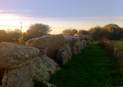
(The Burial Chamber of la Forge near Cherbourg Normandy)
(Neolithic Allée couverte de Bretteville)
The north coast of lower Normandy is largely made from granite and conglomerates of rock that have been formed under great volcanic pressures. You will find these weather resistant rocks everywhere lying on the coastal shores and in the bocage of Normandy. Bocage is a kind of medieval fencing system where the rocks are covered with earth and trees that can stop modern tanks.
(View of Allée couverte de Bretteville at Sunset looking south)
(Plan of site - Table stone on right south side)
The tomb is made from the local Granite and a Triassic conglomerate called pudding stone. Pudding stone looks like a form of modern concrete but it is actually a naturally occurring rock in the area.
(Pudding stone detail from one of the table slabs on top of the Allée couverte de Bretteville).
No further information appears about the tomb until an Excavation and restoration project occurred in the early 1970s. Flints and vase fragments were discovered similar to fragments found in other tombs in Northern France from the Neolithic period thus classifying the megalith as protected. The finds from the tomb are now on display at the Emanuel Liais museum in Cherbourg an interesting and entrance free collection of natural history.
(Off balanced "rickety" table stone on south side of the tomb)
The entrance to the north edge of the tomb was exposed to give access to the first chamber, possibly a funerary chamber. The southern table stone side may also once have been exposed and may have been the burial chamber. No bones were found during the excavations of the 1970s in either chamber possibly due to the acid nature of the soil or more likely due to some sort of human incursion.
The entrance to the north edge of the tomb was exposed to give access to the first chamber, possibly a funerary chamber. The southern table stone side may also once have been exposed and may have been the burial chamber. No bones were found during the excavations of the 1970s in either chamber possibly due to the acid nature of the soil or more likely due to some sort of human incursion.
The bare look of these chambers are really only the remains of the structure. When the Neolithic builders first made the Allée couverte de Bretteville the rock chamber would have been covered in earth and would look like a long or round barrow. The boundaries of the barrow mound that would have surrounded the chamber cannot now be estimated due to the later removal of the perimeter stones that would have marked the tombs exterior.
(Early 20th century postcard of the mound the legend says; Dolmens
(covered way) - we see very clearly on the first traces of ditches).
To me the places where megalithic structures are situated often have a similar feel which seems almost timeless. Often the areas will also have a strong folk history or religious significance with clues being found in path names, sacred trees and of stories people being turned to stone. In general witchcraft and spirit tales are always increased around these areas and this can be another clue when searching for these ancient sites. Locally to this site there are still folk tales of healing trees and magical covens.
(This is a 360 degree view of the Burial Mound at la Forge giving the viewer an idea of how the covered way fits into the surrounding landscape).
The title of the site is paintwalk, I like to walk and paint among other things and what better walk can there be than seeking out the walkways and places of our ancestors. Even though I have lived in the area for 10 years I am still discovering new places in this varied beautiful and complicated landscape. The Google maps grid location of this site is 49.647001, -1.510102 and if you click or copy and paste this into Google maps satellite view you can see the Allée couverte de Bretteville from the road.
Going to normandy this year?
If you're interested in stone circles, standing stones and megaliths in general check out this index. Directions and locations available on each page.
click here
Normandy Megalith The Allee Couverte de Vauville
Normandy Megalith Galerie Couverte de la Petite Roche
http://www.paintwalk.com/2018/04/normandy-megalith-galerie-couverte-de.html
Normandy Megalith - Pierre au Rey
http://www.paintwalk.com/2017/08/normandy-megalith-pierre-au-rey.html
Normandy Megalith Pierre Butée
http://www.paintwalk.com/2017/07/normandy-megalith-pierre-butee.html
Menhir de Champ Dolent Round Scape
http://www.paintwalk.com/2014/08/menhir-de-champ-dolent-brittany.html
A Walking Guide to the Saint Just Alignments
http://www.paintwalk.com/2015/08/a-walking-guide-to-saint-just-alignments.html
Markers - The Saint Just Alignments
http://www.paintwalk.com/2015/08/markers-saint-just-alignments.html
Knowlton Church Landscape Painting Dorset
http://www.paintwalk.com/2014/04/knowlton-church-landscape-painting.html
Hill forts around the Blackmore Vale Dorset
http://www.paintwalk.com/2014/05/hill-forts-around-blackmore-vale.html
Roundscape of des Pierres Droites Standing Stone Alignments Brittany
http://www.paintwalk.com/2014/07/roundscape-of-des-pierres-droites.html
Awakening the Ancestors digital sketches and video of Standing stone alignments in Brittany
http://www.paintwalk.com/2014/07/awakening-ancestors.html
The eye of the lake l'étang de Quéhon
http://www.paintwalk.com/2014/07/the-eye-of-lake-letang-de-quehon_16.html
Paintings and Sketches
The way the path is stopped by stones from paintwalk
9 Barrow Down - Watercolour Sketch from paintwalk
Hillfort sunset watercolour sketch from paintwalk
Monteneuf Standing Stones Water Colour Landscape Brittany
The Avenue Alignments a Decalcomania Painting by Paintwalk


No comments:
Post a Comment