
Welcome to Paintwalk Normandy Megaliths
Megalithic
sites have been fascinating for me since I was a child and have been
linked with my life ever since. Finding them has always been an
important part of my enjoyment and although this has been lot easier
since the advent of GPS I still like locating them by foot if possible.All paintings, music, photos, videos, publishing, and procedures have been a direct result of walking in the open air.
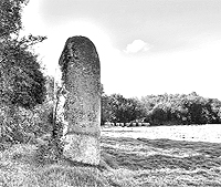
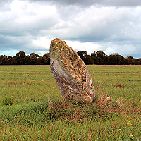
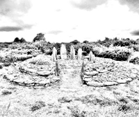
 Normandy Megalith The High Man of Hacouville
The High Man of Hacouville
An endowment of the fairies, claims the legend, is buried in the centre of the emblematic triangle formed by these three stones. The location of the endowment is marked by a lake which is now called "Lake Pelot". The legend concludes that the lake was caused by generations of people searching for the lost endowment, which over time gradually filled up with water until the treasure was lost forever. (Click Image for page)
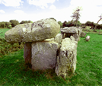
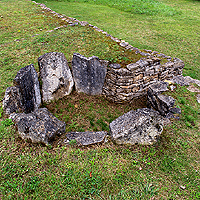
The covered way, Bretteville Normandy
One of the best examples of megaliths in lower Normandy is probably the Allée couverte de Bretteville. The remains of burial chambers are known as Allée couverte (Covered way). The Brettville megalith is a burial chamber near to Cherbourg on the north coast of Normandy just on the edge of Hameau de la Forge. (Click Image for page)
The Long Man of Saint Pierre
Built in the neolithic period (5000 - 2500 B.C). The period of time in which hunter gatherers became part farmers and started to base themselves in the same landscape. This would have also been a time of denser populations when large work such as the erection of this stone could have been more easily undertaken. (Click Image for page)

Normandy Megalith Pierre Butée
The Marsh menhirs have been worked into similar rectangular shapes and stand out well on the flat landscape. The rock used for these menhirs looks different to the stones on the north east coast of Normandy where they are more often a combination of smooth stone and pudding stone - a geological conglomerate. (Click Image for page)
 Normandy Megalith - Pierre au Rey
 Normandy Megalith - Pierre au Rey
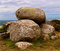
The Normandy west coast cliffs have commanding views over the sea. These steep cliffs are some of the highest in Normandy and landing by boat would be impossible. But thousands of years ago the cliff tops became part of an important settlement for the local people. On these cliff edges they could survey the seas and local islands and by looking inland they could see the rich farmland that would be their sustenance. (Click Image for page)
 Normandy Megalith - Galerie Couverte de la Petite Roche
 Normandy Megalith - Galerie Couverte de la Petite Roche
The
clue is in the name. Rock Town (Rocheville) is a town to the North East
of Briquebec in Basse Normandie. The commune of Rocheville contains a
wooded hill to the South (Map opens in a new window)
that appears to have been a megalithic quarry. The Centre of the wood
is filled with huge boulders and standing stones that are known as the
Grosses Roches. (Click Image for page)
The
Demoiselle was so called because of nocturnal appearances of young
ladies dressed in white, around the Menhir. It is a fact that by the
beautiful moonlight, the silhouette and the light gray coloration of the
Menhir simulate a person covered with a long veil. It is said that
there were once several Menhirs in the area. (Click Image for page)
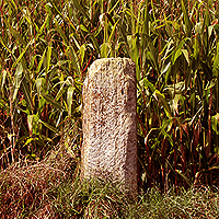 Normandy Megalith Menhir des Planches
The Menhir des Planches is located in Amblie in the department of Calvados. This Menhir might be hard to find because it is set on the far edge of a wheat field and for all its sculpture is not very tall.
A 5cm deep cup is visible at the top as well as parallel channels. (Click Image for page)
 Normandy Megalith The Allee Couverte de Vauville
The Allée Couverte de Vauville, also known as the Pierres Pouquelées is a passage grave to the northwest of the town of Vauville on the Cap de la Hague in the Manche. It is in a great location overlooking the sea, with the rocky cliffs of Cap de la Hague stretching away to the northwest, and the long beach running south from Vauville. (Click Image for page)
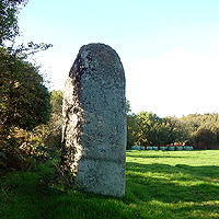
 Normandy Megalith Menhir de Colombiers sur Seulles
At just over 2 metres in height, this Menhir is set in its own little grassy area beside the road junction just uphill to the east of the village of Columbiers-sur-Seulles in Calvados. it is contemporary with Colombiers sur Seulles Long Barrow only one km up the road. (Click Image for page)
 Normandy Megalith Standing Stone at St Pierre Église
la Rue de la Longuemarerie in Saint Pierre Église, really is a remarkable road. This short Single-track lane has seen human habitation on it for over 3000 years. The road begins at one of the old wash-houses known as a "lavoir" they were used from the 17th to the early 20th century. (Click Image for page)
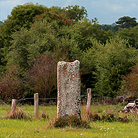
 Normandy Megalith Colombiers sur Seulles Long Barrow
The Menhir des Planches is located in Amblie in the department of Calvados. This Menhir might be hard to find because it is set on the far edge of a wheat field and for all its sculpture is not very tall.
A 5cm deep cup is visible at the top as well as parallel channels. (Click Image for page)
The Allée Couverte de Vauville, also known as the Pierres Pouquelées is a passage grave to the northwest of the town of Vauville on the Cap de la Hague in the Manche. It is in a great location overlooking the sea, with the rocky cliffs of Cap de la Hague stretching away to the northwest, and the long beach running south from Vauville. (Click Image for page)
At just over 2 metres in height, this Menhir is set in its own little grassy area beside the road junction just uphill to the east of the village of Columbiers-sur-Seulles in Calvados. it is contemporary with Colombiers sur Seulles Long Barrow only one km up the road. (Click Image for page)
la Rue de la Longuemarerie in Saint Pierre Église, really is a remarkable road. This short Single-track lane has seen human habitation on it for over 3000 years. The road begins at one of the old wash-houses known as a "lavoir" they were used from the 17th to the early 20th century. (Click Image for page)
The
Tumulus of Colombiers sur Seulles is the oldest and probably biggest
Neolithic funerary monument still preserved in Normandy. The Tumulus
dates from 4000 years BC and is constructed of earth and stones
contained by a series of low walls in dry stones. (Click Image for page)
U.K. Megaliths
U.K. Megaliths
 Hill forts around the Blackmore Vale
Hod and Hambledon Hill
Hod Hill, Hambledon Hill and Rawlsbury Camp are all hill forts on the escarpment around the edges of the Blackmore Vale in Dorset. A description of these forts was noted by the biographer "Suetonius" who travelled with the future Roman Emperor Vespasian during an invasion of England. (Click Image for page)

The Devil Stone Bere Regis
Situated to the south west of Bere Regis on black hill heath, is the Devils stone megalith.
The stone is about 5 and half feet tall (168 cms) and made of a sandstone with an unusual channel in the top that catches rain and condensation. It may have been placed at one point of a ditched barrow, but it it difficult to identify the feature through the gorse. (Click Image for page)
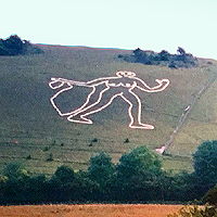
Many people have heard of the Cerne Giant but few have seen the Cerne Giantess. The Cerne Giant is the famous 180 foot naked and club wielding figure carved into the chalk hill.
(Click Image for page)
 Knowlton Church
 Knowlton Church Dorset
Knowlton refers to the long gone village, eventually abandoned and ploughed over. Knowlton church is the abandoned ruin remaining, and Knowlton henge is the Neolithic mounds and ridges surrounding the church and outlying areas, known locally as the Knowlton Rings. (Click Image for page)
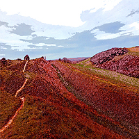 Hod Hill with some digital sketches
 I like visiting megaliths, hill forts and old sites in general. This short film shows the walk and the process of taking something out of the walk. I make music, photographs, prints, sketches, videos in fact anything that will in some way express the time walking.
(Click Image for page)
Brittany Megaliths
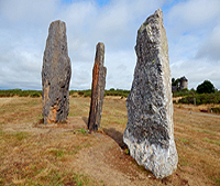
 Roundscape of des Pierres Droites Standing Stone Alignments Brittany
Des Pierres Droites, Montneuf Brittany
The Standing Stones at Monteneuf were put in place around 5000 years ago although the site was not registered as an archaeological monument until 1997. After eight years of excavations looking at the foundation holes at the base of the fallen Menhirs, the stones were finally put back in their original positions. (Click Image for page)

Digital sketches of standing stone alignments in Brittany
If machines are capable of making art, then the copyright owner of art is nature. The diversity of whatever nature is, and the process of you looking at nature is what makes you the artist of this world. This page has video and sketches taken from the alignments at Saint Just and Monteneuf in Brittany. (Click Image for page)
 Menhir de Champ Dolent
 Menhir de Champ Dolent Brittany
In the Champ Dolent or field of woes stands the tallest Standing stone in France. The menhir rises over nine metres and strengthens beliefs suggesting those Bretons were a crazy bunch. The word menhir (Long Man or Long Stone) was adopted from the French by 19th century archaeologists. It is a combination of two words found in the Breton language; men and hir. (Click Image for page)

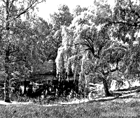
l'étang de Quéhon, Brittany
Water always alludes to the connection between the superficial and the profound. A lake symbolizes a fluid transparent movement, its reflective qualities masking the depths beneath it. With lakes, the enormousness of the seas and oceans are made specific and visible. (Click Image for page)

Cairn Barnenez Finistere
Cairn Barnenez, located in the Finistère region of Brittany, France, stands as a remarkable testament to human ingenuity and architectural prowess. This prehistoric burial mound, dating back several millennia, has captivated the imagination of historians and archaeologists alike.
Markers the Saint Just alignments
The megalithic Sites around Saint Just and Cojoux are fairly unique because of their close proximity to each other and the length of time they were in use. At least nine separate sites in only 10 kilometers with construction and habitation for over 2500 years. If you count the town of Saint Just then this area has been inhabited for 6,500 years. (Click Image for page)
The walking guide to the Saint Just Alignments
the Saint Just alignments are some of the most important megaliths in Europe including the sculptural Chateau Bu Barrow which is the only one of its type in the world. There is surprisingly very little written material about these sites that are all in an area of under 10kms from each other and were built and adjusted for over 2000 years of near continuous occupation. (Click Image for page)
The Avenue a painting by Paintwalk
The
painting shows a stone alignment at night as a line of stones on the
left descend into the distance into a wood. The painting uses a
decalcomania technique using light paints on a dark support giving the
appearance of night. The painting is 23 x 28cm and is framed as shown. (Click Image for page)
Observation post for the ground around Zillebeke and out towards Ypres
Not a megalith but a look at how we sometimes relate to and create our landscapes. Originally there was no hill or lake there at all. The hill was the result of a spoil heap made from the diggings of a railway cutting made for the Ypres–Comines Railway line. The hill remained this way until the out break of the First World War. (Click Image for page)
No comments:
Post a Comment