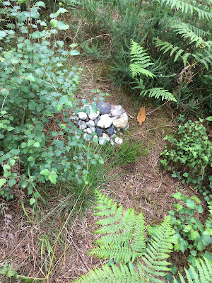
View barrow (50.8089912N, -1.9395161)
Big barrow (walk barrow) (50.8086410N, -1.9379360)
Bronze Age Walks with an iPhone are a collection of short, filmed walks with maps defining Bronze Age sites.
Please take a look at the video https://youtu.be/87vWTWxtgtM
Walk starts at Bridle Way - Google Maps ref (50.8075111, -1.9438680)
 |
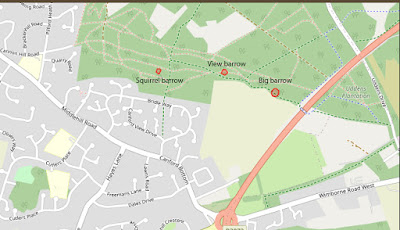
| Map of Cannon Hill Barrows (click to enlarge) |
Walk up the hill until you see an information sign then go left for about 200 yards. The clearing on the right contains the Squirrel barrow so called because, loads of squirrels. The site not been excavated but the low barrow can be made out under the Bracken. If you find this barrow you may find signs of recent visitors. Squirrel barrow is the most hidden of the three Bronze Age barrows.
Next go back to the main path and when you reach it walk up the hill until you come to a crossroads. Turn right and then keep going until you reach a fork. take the left hand route and you will see View barrow within 20 metres.
It’s called View barrow because on the North side is a pretty spectacular vista due to the steep drop looking out over the heath towards Mannington and Cranborne Chase. Nice touch that some seats have been placed here to admire the view.
Take one of the paths back to the fork and go down the hill. if you are on the correct path you should start to see some open farm fields to your right. Keep following this path until you reach a large mound that the path appears to go over.
You are now looking at Big barrow, the largest of the three. There is a path around it that looks like it was forgotten about for years. Now the track has developed to go over it as it became the path of least resistance.
HISTORY
Possibly the three barrows mark a boundary of Bronze Age ownership because two of the three are large and prominent enough to be visible from a distance on the landscape. This is oddly clear today, because they all now reside on a modern boundary. One side is Houses and Farms and the other side is the Cannon Hill Plantation and the heath.
Bronze Age Walks with an iPhone are a collection of short, filmed walks with maps defining Bronze Age sites. The emphasis is on Neolithic, Bronze Age and Iron Age because I find them a good lodestone for a walk.
The walks are usually not a great distance so you don’t have to be super fit to do them. In fact Bronze Age Amble would work. They largely stick to recognisable paths but it is probably a good idea to protect your legs a bit as gorse can be fairly prickly and common in places.
https://historicengland.org.uk/listing/the-list/list-entry/1015999
Historic England Maps and information.
Bronze Age Walks
Cannon Hill 3 Bronze Age Barrows
Summerlug barrow and hill - Holt Heath - Wimborne - Dorset
Bronze Age Walks-Bee-Garden-Holt-Heath
Bronze Age Walks The Oldest living inhabitant in Dorset
https://www.paintwalk.com/2020/08/bronze-age-walks-oldest-living.html


No comments:
Post a Comment